aisvogel: A Bird’s-Eye View of AIS (Automatic Identification System) Data and More
Applications Include Offshore Facilities, Cable Corridors, Energy Infrastructure and Sensitive Maritime Areas
Airborne Sensor Platform Cross-Checks AIS Positions Against Independent Observations, Investigates RF and GNSS Anomalies and Combines Multiple Data Sources into a Maritime Situational Picture
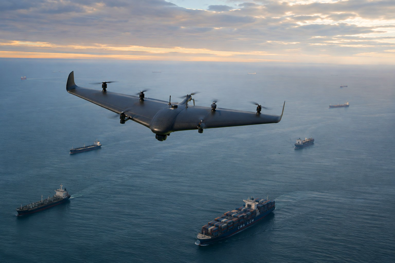
An electronically reported vessel position is, first and foremost, a data point. Determining whether a vessel is actually at that location becomes more reliable when additional, independent information is available. This is precisely where aisvogel from hensec secure solutions comes in. The airborne sensor platform collects RF, positioning, movement, and optical data directly over the maritime area of operation and combines it into a common situational picture.
aisvogel can monitor large maritime areas for many hours, detect unusual signals and movement patterns, and, when required, deploy specifically to locations of interest. In response to alerts or suspicious activity, the platform can launch automatically, fly to the relevant area, and use its sensors to verify the situation on site. With appropriate authorization, the platform can also conduct such missions Beyond Visual Line of Sight (BVLOS). Depending on the mission, the platform can carry RF (radio frequency), AIS (Automatic Identification System), EO/IR (electro-optical/infrared), GNSS (Global Navigation Satellite System), and communications systems. This allows different types of information to be collected, correlated in time and space, cross-checked, and assessed.
“A reliable maritime situational picture requires more than looking at individual data sources in isolation,” said Kevin Heneka, Managing Director of Hensec Secure Solutions. “What matters is where the information comes together: Does the reported position match what is actually observed? Can a suspicious RF emission be geographically narrowed down? And do the different sensors together provide a coherent picture? These are exactly the kinds of tasks we developed aisvogel to address.”
When the Reported Position Does Not Match the Observation
A key application of aisvogel is verifying AIS data. AIS automatically broadcasts vessel information, including identity, position, course, and speed. The platform receives AIS information, analyzes vessel movements, and cross-checks reported positions against additional observations. Camera and EO/IR sensors can independently confirm a contact and compare electronically reported position data with what is actually observed.
When AIS, GNSS, or other positioning information is correlated with a detected contact, location discrepancies become visible. The system can then prioritize and investigate suspicious position jumps, implausible tracks, or potential spoofing incidents in greater detail.
At the same time, the platform can detect relevant RF activity and classify suspicious or unknown radio signals by location and timing. In the GNSS domain, aisvogel can also investigate anomalies and potential jamming or spoofing events in maritime environments. The platform is equipped with GPS-jamming-resilient navigation systems, enabling it to navigate even in interference-affected environments.
Different information sources feed into a dynamic common situational picture. Discrepancies between signals, movements, and observed positions become visible and can be assessed for their operational relevance. For maritime security, this cross-checking of independent information sources is particularly important for reliably assessing anomalies and investigating them further when necessary.
Mobile Sensor Capabilities for Maritime Operations
The CarryAir platform on which aisvogel is based combines the efficiency of a fixed-wing aircraft with the flexibility of a VTOL system. In practice, the aircraft takes off and lands vertically like a helicopter while offering the endurance and efficiency of an airplane in forward flight. With its hybrid propulsion system, it can fly for up to ten hours. The platform has a wingspan of just under three meters and offers a payload capacity of up to seven kilograms, with 60 liters of protected payload volume. Six dedicated lift rotors enable vertical takeoff and landing and provide redundancy.
The sensor configuration can be tailored to the individual mission. The platform can integrate RF, AIS, EO/IR, GNSS, and communications systems, adapting to different operational areas, sensor packages, and mission profiles. As an unmanned sensor platform, aisvogel is also significantly more cost-effective to operate than helicopters or crewed aircraft, particularly for prolonged or recurring surveillance missions.
Potential applications include long-duration mobile monitoring of vessel traffic, shipping routes, and defined areas of operation. In addition, aisvogel can cross-check electronically reported positions and identities against independent airborne observations, investigate unusual RF activity, and detect and geographically investigate potential GNSS jamming and spoofing events in coastal and offshore areas.
The platform is also designed to monitor critical maritime infrastructure while mobile. HENSESC identified potential applications including offshore facilities, cable corridors, energy infrastructure, and sensitive maritime areas. This enables aisvogel to support maritime security across larger areas at sea while also providing targeted protection for particularly sensitive infrastructure. aisvogel is developed and manufactured in Germany, with its entire supply chain located within the European Union.
Multiple Platforms Working Together
One of aisvogel’s key capabilities is deploying multiple airborne platforms cooperatively. Multiple drones operating from geographically separated positions can observe the same signal from different locations and jointly evaluate their measurements.
With the appropriate sensor configuration, this setup enables cooperative direction-finding and geolocation. Multiple platforms provide different lines of bearing that can geographically narrow the source of a suspicious emission. At the same time, additional platforms can monitor the surrounding maritime area or optically verify a contact.
A Bird’s-Eye View as a Key Advantage in Maritime Surveillance
“Mobility is a crucial advantage at sea,” explains Heneka. “Instead of relying solely on what can be detected from a fixed location, we bring the sensors directly over the area of operation to provide a comprehensive bird’s-eye view. And when multiple platforms work together, we can examine a suspicious situation from different positions and combine the information they collect.”
The mission workflow follows a consistent principle: we first collect sensor data, then correlate it in time and space, classify anomalies, and prioritize them. Operators can then cross-check electronic information against optical observations or other independent sensor data. Multiple platforms can then investigate suspicious contacts and signal sources in greater detail and narrow them down geographically through cooperative use.