
Baltic Sea countries are stepping up their cooperation to protect against hybrid threats. At the Baltic Sea Security Summit in late August, Germany, Denmark, Estonia, Finland, Latvia, Lithuania, Poland, Sweden and Norway agreed to intensify information sharing and establish a joint task force. Shared situational awareness and compatible security technologies are also moving higher up the agenda. Ports play a particularly important role: As hubs for logistics, energy supply, industry, and data connections, they are among the most sensitive areas of critical infrastructure.
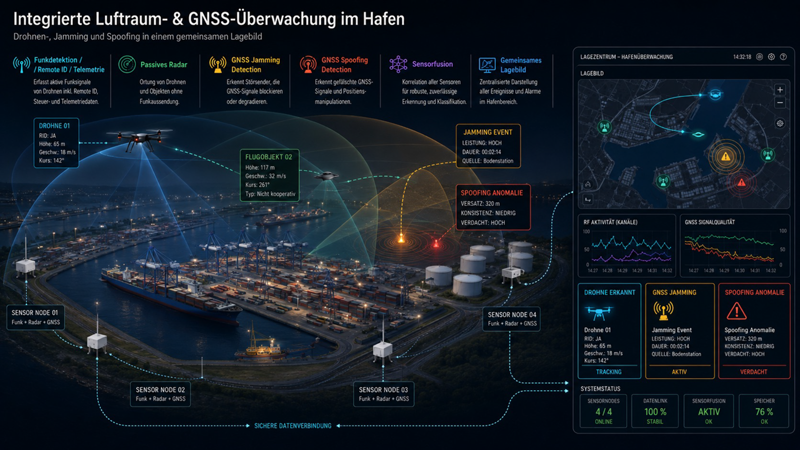
To help protect this infrastructure, German security company hensec secure solutions has developed Portags (Port Airspace and GNSS Security). Designed specifically for ports, the integrated airspace and Global Navigation Satellite System (GNSS) monitoring platform combines multiple detection technologies in one operational view. Put simply, the system monitors the airspace above a port for potential airborne objects such as drones, while simultaneously checking whether satellite navigation signals are reliable or being disrupted. This enables security teams to centrally detect, assess and document drone activity and GNSS interference.
“Shared situational awareness isn’t achieved simply by installing more and more individual sensors. What matters is bringing their data together, correlating it and presenting it in a way that allows security teams to understand what is actually happening quickly,” said Kevin Heneka, Managing Director of Hensec Secure Solutions. “Particularly in complex port environments, it is essential not to look at different sources of information in isolation, but to understand how they relate to one another.”
From Individual Signals to a Common Operating Picture
Portags combines several detection technologies. RF sensors monitor relevant frequency ranges and detect active drone communication and control signals. These include Remote ID data, control and communication signals, and telemetry and movement information. Passive radar complements this data by making non-transmitting and non-cooperative airborne objects visible.
At the same time, the system monitors the GNSS environment. Jamming occurs when GNSS signals are overlaid, blocked, or severely degraded. With spoofing, receivers receive plausible but false navigation or time information. The proprietary GNSS analysis systems integrated into Portags analyze signal quality, detect interference and anomalies, and perform plausibility checks to identify and classify suspicious events.
According to Hensec, GNSS interference can affect not only navigation, but also synchronization and automated processes. Potentially affected areas include maritime and air traffic, critical infrastructure, communications systems and autonomous systems that depend on reliable positioning or timing information.
Sensor fusion brings together, correlates, and classifies RF, radar, telemetry, and GNSS data. The system then displays relevant information centrally in a Common Operating Picture. Incidents can be visualized, alerts generated and a traceable event record maintained.
GNSS Interference in the Baltic Sea Region
Research involving hensec also demonstrates the relevance of GNSS interference to maritime security. During a 2025 measurement campaign, a GNSS interference detector was installed aboard a research vessel operating in the southern Baltic Sea between June and October.
The measurements identified combined jamming and spoofing activity, among other interference types. In some cases, the study measured significantly stronger interference at sea than in the Port of Gdansk. The study shows that vessels in the Baltic Sea region are at times exposed to complex GNSS interference.
“Where drone activity and interference with navigation signals can occur at the same time, relying on a single sensor source is not enough,” Heneka explained. “Portags therefore takes a multi-sensor approach: Different data sources are brought together and checked for plausibility, giving security teams a reliable basis for assessing the situation.”
Modular, Scalable and Integrable
The Portags sensor architecture is designed around the specific site, risk profile, and required coverage. The system is modular and scalable and can be deployed in either stationary or mobile configurations.
Potential applications include container terminals, tank farms, port entrances and automated terminals. The system can also monitor critical energy, communications, and control infrastructure.
Open interfaces allow Portags to be integrated into existing operations centers. Multiple sensor nodes can be connected via a secure data network, bringing the information together in a Common Operating Picture.
Portags therefore takes an integrated approach to port monitoring: detecting drones, identifying GNSS interference, and bringing together different sources of information so that security situations can be assessed centrally and fast, and informed decisions can be made.